superd
No life here!

Posts: 24
|
Post by superd on Jul 10, 2008 0:54:11 GMT -5
How about a bag of apples and a harmonica?
|
|
vilnoori
Really into this!
 Bone Collector
Posts: 547
|
Post by vilnoori on Jul 10, 2008 20:29:57 GMT -5
;D Wow, that is some road.  er, track. Wish'd I'd had a burro. Yes, there is now a bag of apples up there. And garlic. However, I'm not going up there again unless I have 4WD and a much smaller vehicle with a higher chassie. And certainly not at night. That was one intrepid couple! And yes, in answer to the question, it is steep. Very. While they were coming down they would have to have been going extremely slowly in first, so there was plenty of time for quatchie to saunter across the road if he chose. |
|
beegee
No life here!
Posts: 28
|
Post by beegee on Jul 12, 2008 11:47:28 GMT -5
I see the Chilliwack Progress ran the article about the sighting in friday's paper, it had a photograph of Bill Miller and Thomas Steenburg in the area it was seen in. It was written up by Ashley Wray, I thought it at least was a unbiased account and very well done, ---- no tongue in cheek stuff, which is unusual to say the least, so now "look out" for the throngs of Sassy hunters for a while, until this sighting dies down, please be careful out there as there have also been reports of a Bear also in the area..........
|
|
vilnoori
Really into this!
Bone Collector
Posts: 547
|
Post by vilnoori on Jul 12, 2008 20:04:05 GMT -5
Oh yeah! Not a bad article. Except there aren't any pines, so therefore no pine needles there. But it doesn't give the location. One to scan for the files! Congrats to Thomas and Bill! Sheesh I guess I should read that thing more often instead of just using it to put on the floor when I'm painting.
|
|
beegee
No life here!
Posts: 28
|
Post by beegee on Jul 13, 2008 17:07:01 GMT -5
Vilnoori you seem to be a whiz with these google maps etc, have you considered this as a scenario, ------- Take the location at which Thomas found the footprints a few years ago near the Chilliwack river, he's given the actual location in a prior posting, and take an aproximate direction which follows Cow/ Cattle creek, or a logical path through the terrain, would it end up lets say in a close proximity to Bridal Falls,  (last location seen). I believe that the Honomids we're seeking, have "set pathways" (or shall we call them "SASSPATHS"), which they use on a constant basis to collect food at different times of the year, these Sasspaths would be have been used for generations, and unless disturbed by some natural disaster, will continue to do so. It's one of these Sasspaths that we need to find, and its there we should be utilising remote cameras etc, etc, audio recorders, and what ever else we've got to acheive proof positive that "our prey" without doubt is alive and kicking. It would be or could be a little like "connect the dots", ------- c'mon guys, help find me a "Sasspath". ------Hopefully this will spark some interest for some of the computer guru's, and a number of Sasspaths may be found over by Chehalis --- Ruby Creek ---- look at all sightings, the answer may be closer than you think........... |
|
superd
No life here!
Posts: 24
|
Post by superd on Jul 13, 2008 19:18:05 GMT -5
Would that news article be online?
Beegee, do you watch that Tv program, Numbers? Wish it was that simple. But good Idea just the same.
|
|
beegee
No life here!
Posts: 28
|
Post by beegee on Jul 13, 2008 22:20:21 GMT -5
Hey Superd....... Don't know if they will have the article "on line" but, I have scanned it and if you want a copy let me know, and I will gladly email it off to you..............
|
|
vilnoori
Really into this!
Bone Collector
Posts: 547
|
Post by vilnoori on Jul 13, 2008 23:41:53 GMT -5
I don't know if you recall the old First Nations tales about Sas using waterways as paths? How they'd make like a log and float down them? And given their incredible ability to traverse slopes and other difficult terrain such as cliffs and bogs, I don't know that I think they have set trails. And if so, what criteria do we look for: low terrain, high level terrain, etc? But I'll post a pic of the general area so you can get a picture of the terrain and figure it out for yourselves. Popkum to Harrison Area, including Bridal Falls, Cheam Mountain etc. I circled likely areas where there is a lot of forest adjacent to the highway, and where the river becomes a number of narrow rivulets so it is a likelier area for them to cross: 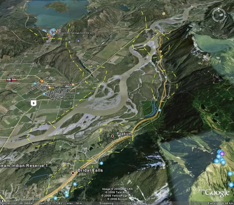 Next, Chilliwack River and the creek valleys that feed it: 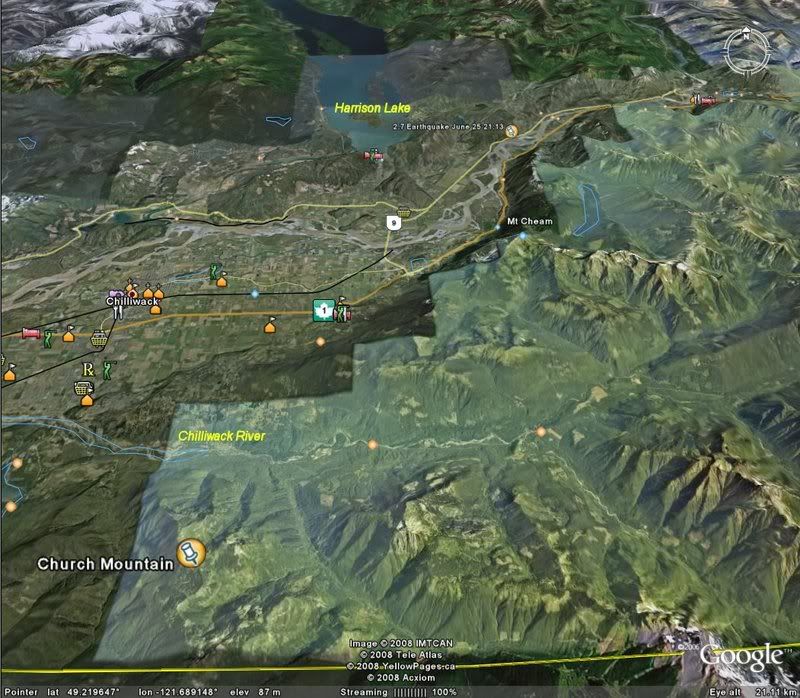 Lastly, Chilliwack Lake area: 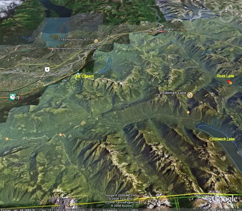 Sorry guys, photo heavy, and these are big ones too. But I think well worth the waiting time. |
|
vilnoori
Really into this!
Bone Collector
Posts: 547
|
Post by vilnoori on Jul 13, 2008 23:58:06 GMT -5
And by the way, if I had to walk from the US border to Harrison Hot Springs, the quickest way would be to take Slesse Creek FSR, walk down the Chilliwack River Rd. to the Chipmunk Penninsula crossing of the Chilliwack River, then head up Chipmunk Creek FSR, which just happens to turn into Bridal Falls FSR. Then cross the #1 Highway where there is lots of bush, and late at night (say 2 PM) when there's very little traffic, rest up beside the river nibbling on some fish, then find a spot where the river narrows (best to cross during times when the river is lowest, like September-October) in spots that I've circled. A lot of these areas have had BF sighting reports, by the way.
|
|
beegee
No life here!
Posts: 28
|
Post by beegee on Jul 14, 2008 1:21:37 GMT -5
Must commend you Vilnoori ---- that's one excellent piece of work, it will take me some time to review and digest them, ---- THANK YOU!!! --- So now if natures overall intent is to conserve energy then the easiest route would be the most plausible for our friend to follow, Small creeks are natural paths through our wild terrain, and some of those Alpine valley's are ideal candidates for sasspaths. Of course the idea is still pure conjecture, but also I think there's a nucleus of great talent that are involved on this forum, that ultimately could come up with "the right answers". I would prefer it to be in our lifetimes, so we must explore any avenue no matter if it follows our specific guidelines or not... Keep up the good - no great work...
|
|
superd
No life here!
Posts: 24
|
Post by superd on Jul 14, 2008 1:23:29 GMT -5
Yes beegee, I'd like a copy of that article, please send to superdav@telus.net
vilnoori, great job of capturing those maps and editing , very informative.
|
|
vilnoori
Really into this!
Bone Collector
Posts: 547
|
Post by vilnoori on Jul 15, 2008 17:00:19 GMT -5
Oh, and another thing, both Mt. McGuire (next to the Slesse Creek corridor) and Church Mountain (to the West of it) are limestone rich areas, so full of caves. Chipmunk caves are quite close to the place where Slesse creek empties into Chilliwack River, all that area is full of karstic outcroppings. Sebastian, if you are into digging up sas bones, that would be a prime place to look.  That is, if you are finished looking into that cave up by Golden Ears. |
|
|
|
Post by mooseman on Jul 17, 2008 4:23:13 GMT -5
Great to have a new local sighting, thanks for the work Thomas.
|
|
|
|
Post by Gerry on Jul 21, 2008 18:53:36 GMT -5
Thomas's server is on the blink..or rather his modem. So cannot send or receive email for the past week or so. Or get online! We are working on it!
He asked me to pass this along!
|
|
cherni
No life here!
Posts: 31
|
Post by cherni on Jul 27, 2008 23:56:15 GMT -5
Anyone else, besides me hear it on Coast to Coast AM? They had it on there.
Also, my brother inlaw is a prison guard up there. He says some of his fellow guards ran into the people who saw the Squatch. His collegues said they were just shaking out of fear. Also he says it's now a topic of conversation, so now when the guards are on patrol, they're now not just looking for Cons but Big Foot as well.
|
|


 er, track. Wish'd I'd had a burro. Yes, there is now a bag of apples up there. And garlic. However, I'm not going up there again unless I have 4WD and a much smaller vehicle with a higher chassie. And certainly not at night. That was one intrepid couple! And yes, in answer to the question, it is steep. Very. While they were coming down they would have to have been going extremely slowly in first, so there was plenty of time for quatchie to saunter across the road if he chose.
 (last location seen). I believe that the Honomids we're seeking, have "set pathways" (or shall we call them "SASSPATHS"), which they use on a constant basis to collect food at different times of the year, these Sasspaths would be have been used for generations, and unless disturbed by some natural disaster, will continue to do so. It's one of these Sasspaths that we need to find, and its there we should be utilising remote cameras etc, etc, audio recorders, and what ever else we've got to acheive proof positive that "our prey" without doubt is alive and kicking. It would be or could be a little like "connect the dots", ------- c'mon guys, help find me a "Sasspath". ------Hopefully this will spark some interest for some of the computer guru's, and a number of Sasspaths may be found over by Chehalis --- Ruby Creek ---- look at all sightings, the answer may be closer than you think...........
 That is, if you are finished looking into that cave up by Golden Ears.

